AMEZON FORERST
he Amazon rainforest (Portuguese: Floresta Amazônica or Amazônia; Spanish: Selva Amazónica, Amazonía or usually Amazonia; French: Forêt
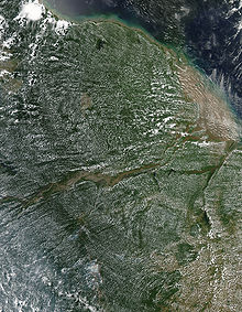
 amazonienne; Dutch: Amazoneregenwoud), also known in English as Amazonia or the Amazon Jungle, is a moist broadleaf forest in the Amazon biome that covers most of the Amazon basin of South America. This basin encompasses 7,000,000 km2 (2,700,000 sq mi), of which 5,500,000 km2(2,100,000 sq mi) are covered by the rainforest. This region includes territory belonging to nine nations. The majority of the forest is contained within Brazil, with 60% of the rainforest, followed by Peru with 13%, Colombia with 10%, and with minor amounts in Venezuela, Ecuador, Bolivia, Guyana, Suriname and French Guiana. States or departments in four nations contain "Amazonas" in their names. The Amazon represents over half of the planet's remaining rainforests,[1] and comprises the largest and most biodiverse tract of tropical rainforest in the world, with an estimated 390 billion individual trees divided into 16,000 species.[2]
NATURAL
The rainforest likely formed during the Eocene era. It appeared following a global reduction of tropical temperatures when the Atlantic Ocean had widened sufficiently to provide a warm, moist climate to the Amazon basin. The rainforest has been in existence for at least 55 million years, and most of the region remained free of savanna-type biomes at least until the current ice age, when the climate was drier and savanna more widespread.[4][5]
Following the Cretaceous–Paleogene extinction event, the extinction of the dinosaursand the wetter climate may have allowed the tropical rainforest to spread out across the continent. From 66–34 Mya, the rainforest extended as far south as 45°. Climate fluctuations during the last 34 million years have allowed savanna regions to expand into the tropics. During the Oligocene, for example, the rainforest spanned a relatively narrow band. It expanded again during the Middle Miocene, then retracted to a mostly inland formation at the last glacial maximum.[6] However, the rainforest still managed to thrive during these glacial periods, allowing for the survival and evolution of a broad diversity of species.[7]
During the mid-Eocene, it is believed that the drainage basin of the Amazon was split along the middle of the continent by the Purus Arch. Water on the eastern side flowed toward the Atlantic, while to the west water flowed toward the Pacific across the Amazonas Basin. As the Andes Mountains rose, however, a large basin was created that enclosed a lake; now known as the Solimões Basin. Within the last 5–10 million years, this accumulating water broke through the Purus Arch, joining the easterly flow toward the Atlantic.[8][9]
There is evidence that there have been significant changes in Amazon rainforest vegetation over the last 21,000 years through the Last Glacial Maximum (LGM) and subsequent deglaciation. Analyses of sediment deposits from Amazon basin paleolakes and from the Amazon Fan indicate that rainfall in the basin during the LGM was lower than for the present, and this was almost certainly associated with reduced moist tropical vegetation cover in the basin.[10] There is debate, however, over how extensive this reduction was. Some scientists argue that the rainforest was reduced to small, isolated refugia separated by open forest and grassland;[11] other scientists argue that the rainforest remained largely intact but extended less far to the north, south, and east than is seen today.[12] This debate has proved difficult to resolve because the practical limitations of working in the rainforest mean that data sampling is biased away from the center of the Amazon basin, and both explanations are reasonably well supported by the available data.
AMIMALS AND BIODIVERSTIN
Biodiversity
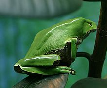
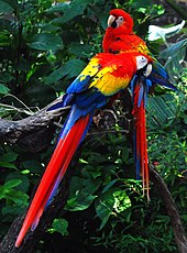
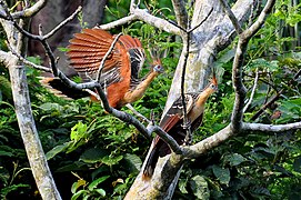
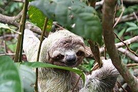
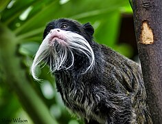
Wet tropical forests are the most species-rich biome, and tropical forests in the Americas are consistently more species rich than the wet forests in Africa and Asia.[29] As the largest tract of tropical rainforest in the Americas, the Amazonian rainforests have unparalleled biodiversity. One in ten known species in the world lives in the Amazon rainforest.[30] This constitutes the largest collection of living plants and animal species in the world.
The region is home to about 2.5 million insectspecies,[31] tens of thousands of plants, and some 2,000 birds and mammals. To date, at least 40,000 plant species, 2,200 fishes,[32] 1,294 birds, 427 mammals, 428 amphibians, and 378 reptiles have been scientifically classified in the region.[33] One in five of all bird species are found in the Amazon rainforest, and one in five of the fish species live in Amazonian rivers and streams. Scientists have described between 96,660 and 128,843 invertebrate species in Brazil alone.[34]
The biodiversity of plant species is the highest on Earth with one 2001 study finding a quarter square kilometer (62 acres) of Ecuadorian rainforest supports more than 1,100 tree species.[35] A study in 1999 found one square kilometer (247 acres) of Amazon rainforest can contain about 90,790 tonnes of living plants. The average plant biomass is estimated at 356 ± 47 tonnes per hectare.[36] To date, an estimated 438,000 species of plants of economic and social interest have been registered in the region with many more remaining to be discovered or catalogued.[37] The total number of tree species in the region is estimated at 16,000.[2]
The green leaf area of plants and trees in the rainforest varies by about 25% as a result of seasonal changes. Leaves expand during the dry season when sunlight is at a maximum, then undergo abscission in the cloudy wet season. These changes provide a balance of carbon between photosynthesis and respiration.[38]
The rainforest contains several species that can pose a hazard. Among the largest predatory creatures are the black caiman, jaguar, cougar, and anaconda. In the river, electric eels can produce an electric shock that can stun or kill, while piranha are known to bite and injure humans.[39] Various species of poison dart frogs secrete lipophilic alkaloid toxins through their flesh. There are also numerous parasites and disease vectors. Vampire bats dwell in the rainforest and can spread the rabiesvirus.[40] Malaria, yellow fever and Dengue fever can also be contracted in the Amazon region.
Remote sensing
The use of remotely sensed data is dramatically improving conservationists' knowledge of the Amazon basin. Given the objectivity and lowered costs of satellite-based land cover analysis, it appears likely that remote sensing technology will be an integral part of assessing the extent and damage of deforestation in the basin.[61]Furthermore, remote sensing is the best and perhaps only possible way to study the Amazon on a large-scale.[62]
The use of remote sensing for the conservation of the Amazon is also being used by the indigenous tribes of the basin to protect their tribal lands from commercial interests. Using handheld GPS devices and programs like Google Earth, members of the Trio Tribe, who live in the rainforests of southern Suriname, map out their ancestral lands to help strengthen their territorial claims.[63] Currently, most tribes in the Amazon do not have clearly defined boundaries, making it easier for commercial ventures to target their territories.
To accurately map the Amazon's biomass and subsequent carbon related emissions, the classification of tree growth stages within different parts of the forest is crucial. In 2006 Tatiana Kuplich organized the trees of the Amazon into four categories: (1) mature forest, (2) regenerating forest [less than three years], (3) regenerating forest [between three and five years of regrowth], and (4) regenerating forest [eleven to eighteen years of continued development].[64] The researcher used a combination of Synthetic aperture radar (SAR) and Thematic Mapper (TM) to accurately place the different portions of the Amazon into one of the four classifications.






Nice Bro...
ReplyDeleteTHANKS KOLLO
ReplyDeletegood topic
ReplyDelete